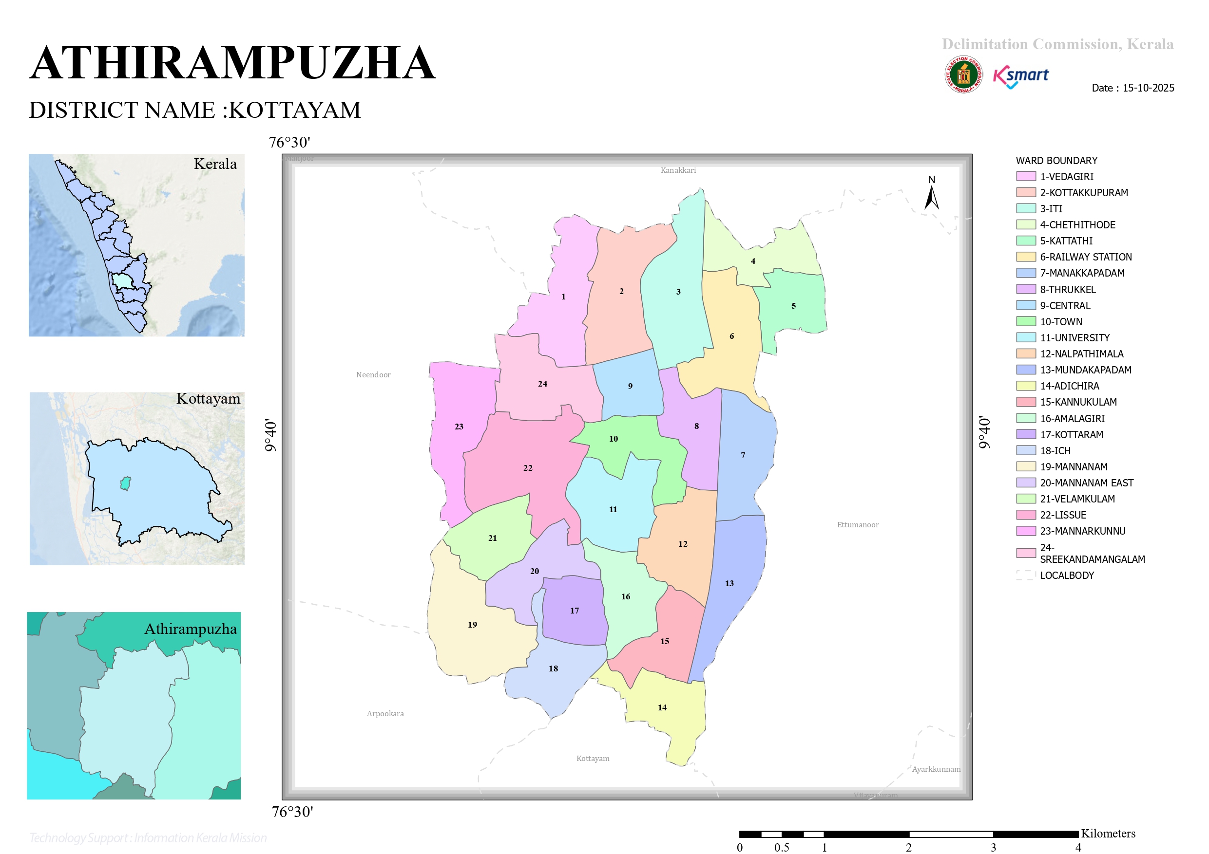

Map 2026
Athirampuzha Grama Panchayat Ward Division Final Order 2025
Comprehensive study report on the final division and delimitation of the 24 wards of Athirampuzha Grama Panchayat published by the Kerala Delimitation Commission
1. Introduction
The Delimitation Commission has issued a final order to redistrict the wards in Athirampuzha Grama Panchayat in Kottayam district, taking into account the population and geographical boundaries, as per the provisions of the Kerala Panchayat Raj Act, 1994. The re-delimitation of the wards was done on the basis of fixing the number of members to be elected through direct elections in the panchayat at 24.
Total Wards
24
Order Date
15
May 2025
District
Kottayam
2. Key features of the order
- Athirampuzha Grama Panchayat was divided into 24 wards.
- Each ward was given a specific name, population and boundary.
- The final order was published after examining the complaints and suggestions received from the public.
- The division was made considering administrative and geographical factors.
3. List of wards
| Ward Number | Ward Name | Population |
|---|---|---|
| 1 | Vedagiri | 1,582 |
| 2 | Kottakkupuram | 1,642 |
| 3 | ITI | 1,510 |
| 4 | Chethithodu | 1,516 |
| 5 | Kattathy | 1,561 |
| 6 | Railway Station | 1,794 |
| 7 | Manakkapadam | 1,734 |
| 8 | Thrikkel | 1,671 |
| 9 | Central | 1,534 |
| 10 | Town | 1,645 |
| 11 | University | 1,799 |
| 12 | Nalpathimala | 1,770 |
| 13 | Mundakapadam | 1,719 |
| 14 | Adichira | 1,841 |
| 15 | Kannukulam | 1,674 |
| 16 | Amalagiri | 1,561 |
| 17 | Kottaram | 1,805 |
| 18 | I C H | 1,537 |
| 19 | Mannanam | 1,716 |
| 20 | Mannanam East | 1,788 |
| 21 | Velamkulam | 1,740 |
| 22 | Lissue | 1,823 |
| 23 | Mannarkunnu | 1,579 |
| 24 | Sreekandamangalam | 1,653 |
4. Demographic analysis
The Largest Population
Adhira Ward – 1,841
Second Highest
Lisue Ward – 1,823
Third Highest
Kottaram Ward – 1,805
Minimum Population
ITI Ward – 1,510
5. Key Observations
- An attempt has been made to maintain a roughly balanced population of wards.
- Geographical landmarks such as major roads, railway lines, canals, junctions etc. have been used.
- Representation between urban and rural areas has been ensured.
- Separate wards have been allotted to developed areas such as University, Town, Mannanam, Amalagiri and Adhira.
- The division was implemented with the aim of administrative efficiency and electoral convenience.
6. Conclusion
The final division of the 24 wards in Athirampuzha Grama Panchayat has been carried out considering the population balance and geographical boundaries. It is hoped that this re-determination will make future local government elections more efficient and representative.