
Map 2015
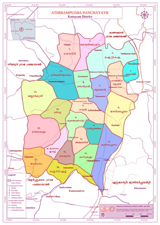
Athirampuzha Grama Panchayat Ward Map
Comprehensive ward-based administrative and geographical map database of Athirampuzha Grama Panchayat
General Description
The image given above is a ward-based administrative map of Athirampuzha Grama Panchayat. The geographical boundaries and ward divisions of Athirampuzha Grama Panchayat, which functions under Ettumanoor Block Panchayat of Kottayam District, are clearly shown in this map.
Total Wards
22
Administrative area
Ettumanoor
District
Kottayam
Important information on the map
- The Panchayat is divided into a total of 22 wards.
- Each ward is marked in a different color.
- Major roads, railways, junctions, and institutions are included.
- The name, number, and boundaries of the wards are clearly shown.
- Compass, legend, and scale are included.
Earth's Boundaries
East
Ettumanoor Area
West
Neendoor and Arpookkara areas
North
Kanakari Panchayat
South
Kumaranallur and Kottayam areas
Important places included in the map
🚉 Railway
Ettumanoor Railway Station
🛣 Road Connection
MC Road Connection
🏥 Health Sector
Medical College Section
💧 Water Sources
Major water bodies and canals
🏫 Education
Educational institutions
⛪ Places of worship
Temples, churches, and shrines
Administrative Importance
- Ward-based development activities
- Voter list preparation
- Sanitation and waste management activities
- Road and drinking water project formulation
- Disaster management activities
- Tax, survey, population studies
Speciality
The Panchayat Administrative Boundary is drawn in beautiful colors, making it easy for the public and officials to understand. It serves as an important official document for the administration and development plans.
Conclusion
This ward map is an important official document that illustrates the comprehensive administrative structure and territorial divisions of Athirampuzha Grama Panchayat. It serves as a basic source of information for Panchayat development projects and public services.